
01
Rutundu Log Cabins
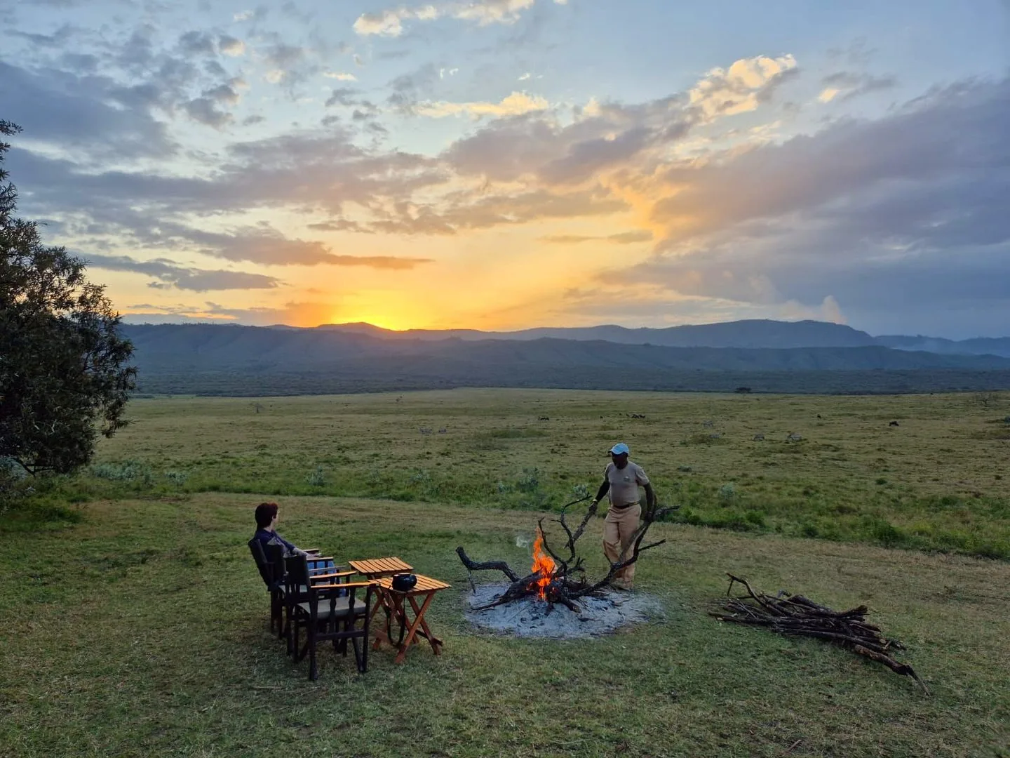
Sunbird at Breakfast The story that defined it: On the night of 20 October 2010, Prince William drove up from the Lewa Wildlife Conservancy to two small cedarwood cabins on the shore of Lake...

Destination Guide
Mountain forests, highland air, adventure routes, wildlife corridors, and lodges around Mount Kenya.
Destination Guide
Africa's second-highest mountain rises to 5,199 metres above a landscape of equatorial forest, moorland, and glacial tarns. The conservancies and lodges on the mountain's lower slopes offer a cool-air safari experience unlike anywhere else in Kenya, with wildlife corridors that connect the highlands to the vast northern frontier.
Overview
A clear introduction to the landscape, rhythm, and reason this destination matters.

Overview
The prediction of leading glaciologists, confirmed by UNEP, UNESCO and multiple independent research teams: Mount Kenya's glaciers will disappear entirely before 2030. Some scientists believe they may be gone sooner. The Human Cost: The glaciers' disappearance is not only an aesthetic tragedy. It is a water crisis in slow motion.
Overview
Lewis Pugh and the Current Campaign: In December 2025, Lewis Pugh — UN Environment Programme Goodwill Ambassador and endurance swimmer climbed Mount Kenya to stand beside the Lewis Glacier and speak directly about its condition. His assessment, given to Reuters: "The Lewis Glacier is right on the edge now.
Overview
So, we cannot be quiet on the disappearance of Africa's last glaciers." UNESCO hydrologist Alexandros Makarigakis has stated plainly: "Pretty soon we will have a generation that will never associate Africa with glaciers." What This Means for a Vard Africa Client in 2026: To climb Mount Kenya today and see the Lewis Glacier two small blocks of ice in a

Overview
You feel it physically: the lungs working harder, the pace slowing, the specific quality of exhaustion at 4,000 metres that is different from any tiredness at sea level. The body earns the summit. ✓ It is about botany of another world.
Overview
At 4,000 metres in the Afro-alpine zone of Mount Kenya, in the hour before dawn on the summit morning, the silence is total. The Laikipia plains are invisible below. The other trekkers are not there; there are no other trekkers. There is the trail, the headlamp, the cold and the specific silence of a place where almost nobody ever goes.

Overview
The specific opportunity to stand beside the Lewis Glacier to see what 4.2% of original ice coverage looks like in a valley that was once entirely filled with ice exists for a very short remaining window of time.

Overview
Giant lobelia (Lobelia telekii): up to 6 metres tall, a rosette of stiff, grey-green leaves arranged around a central spike of hundreds of blue flowers, pollinated by birds rather than bees (there are no bees at this altitude).

Overview
This is what guests see in the final hours before the summit: the headlamp beam on black rock, the cold at -10°C or below, the specific darkness of a pre-dawn equatorial high-altitude, and if they look up the stars through the thin, clear air at 4,000+ metres that are the finest night sky available anywhere on the Kenya journey.

Overview
The interiors are dark, warm, cedar-scented and fire-lit — the open log fires the primary heating source, the solar hurricane lamps the primary lighting. The word most accurately applied: rough-luxe — a deliberate, honest roughness that is entirely different from a compromise.

Overview
Both cabins must be booked simultaneously as there is only one kitchen. Self-Catering: Rutundu is fully self-catering. There is no restaurant, no shop and no provisions. Guests bring all their food and drink.

Overview
We work with Elizabeth at Olepangi or with Nanyuki provisioning teams to assemble a specific menu for the cabin stay fresh produce, proteins, cheeses, wines, spirits, snacks, the specific ingredients for meals guests have requested packed into cool boxes for the transfer. The resident staff's cooking makes the self-catering arrangement as close to hosted as the format allows.
Overview
The specific fitness demands are: sustained aerobic capacity (the ability to walk uphill for hours), leg strength (for the ascent grades and the scree on summit day) and the psychological capacity to continue when the body is uncomfortable.

Overview
Evening and night: The clouds often clear again at sunset, and the nights are typically clear and cold, with temperatures below freezing above 4,000 metres throughout the year. This pattern is why all summit attempts begin at 2am–3am — reaching the summit at dawn, during the clear window before the clouds build, is the standard practice on all routes.

Overview
Trails are firm and dry, visibility is good, summit temperatures are predictable and manageable. September and October are particularly recommended: the summer crowds from July–August have dispersed while conditions remain excellent. Temperatures are slightly cooler than January-February: daytime lows of 14–20°Cat base altitude. Summit nights reach -12°C to -15°C. Vard Africa Recommendation: ★★★★★ — Optimal. Particularly September.

Overview
The Techniques The general principle: Kenya trout are drift feeders in the daytime they hold in the fast water at the head of pools; in the evening they move to the tails and begin surface feeding. Plan early sessions for nymph fishing in the faster water; late afternoon for dry fly presentations at the pool tails.
Overview
Why Combine with Sirimon: The Chogoria-Sirimon traverse is Mount Kenya's most recommended itinerary ascending via the Chogoria's spectacular eastern approach and descending via the Sirimon's gradual, comfortable western route.
Overview
The Lower Risk of Acclimatisation Failure: The Naro Moru's fast ascent profile is the second significant risk. Rising from 2,000m to 4,200m in two days is faster than the Sirimon or Chogoria approach, giving the body less time to adapt to altitude.
Overview
The rate of altitude sickness-related descents on the Naro Moru is higher than on either the Sirimon or Chogoria. Vard Africa always recommends the 5-day Naro Moru itinerary over the 3-day option — the additional day at Met Station before the summit push significantly improves success rates and enjoyment.
Overview
It was re-opened in the early 1990s by a small number of dedicated operators, and it has remained ever since the province of true wilderness aficionados who understand what they are choosing.
Overview
Note on the Sirimon–Chogoria direction: This direction (Sirimon up, Chogoria down) allows the descent via the Gorges Valley which is more dramatic seen from above on the way down than from below on the way up. Both directions are excellent; this is Vard Africa's preferred sequence.
Overview
✓ Day 4 — Shipton's Camp (4,200m) to Old Moses Camp and Sirimon Gate Comfortable descent via the Sirimon Route through the Liki North Valley to Old Moses Camp and then to the Sirimon Gate. Vehicle transfer back to Nanyuki. Duration: 5–7 hours.
Overview
The Vertical Bog is the defining challenge; the summit push from MacKinder's is the most direct of any route; the Sirimon descent provides a comfortable return. ✓ Day 1 — Naro Moru Gate (2,590m) to Met Station (3,050m) Drive to the Naro Moru Park Gate (40 minutes from Nanyuki).
Overview
Teleki Valley and follows it to MacKinder's Camp (4,200m). Duration: 7–9 hours. An acclimatisation walk above camp before dinner is strongly recommended. Distance: approximately 10km. Altitude gain: 1,150m. ✓ Day 3 — Summit Day: MacKinder's Camp to Point Lenana and Descent to Shipton's Departure at 2am from MacKinder's via the South Face approach. Summit at dawn.
Overview
Equipment: Sleeping bag rated to -10°C minimum (Vard Africa recommends -15°C for summit night); trekking poles (strongly recommended); headlamp with fresh batteries and spare; sunscreen SPF50+; sunglasses (UV protection essential at altitude); personal first aid kit; water bottles or hydration bladder (minimum 2 litres capacity).
Overview
You feel the altitude in your lungs and in the quality of your sleep. You feel the cold at 4,200 metres in the hours before dawn when the temperature has dropped to -10°C and the headlamp is the only light in the darkness.
Hotels & Lodges
Hotels, lodges, camps, villas, private houses, facilities, room styles, dining, and the accommodation details guests need before choosing a route.
17 partner properties in Mount Kenya
Sunbird at Breakfast The story that defined it: On the night of 20 October 2010, Prince William drove up from the Lewa Wildlife Conservancy to two small cedarwood cabins on the shore of Lake...

The Kenya Wildlife Service operates and maintains a series of mountain huts along the three main routes. These are not luxury accommodation; they are proper mountain huts in the tradition of alpine climbing lodges...
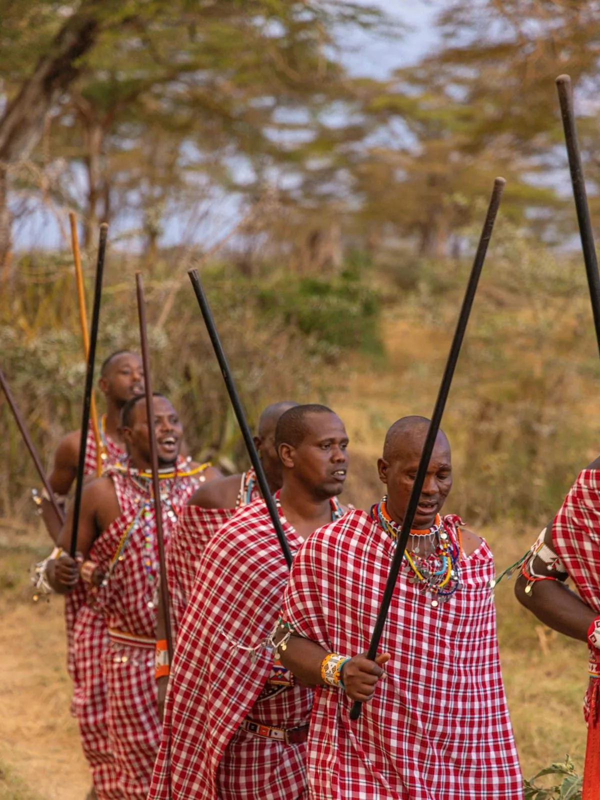
Glaciers Are Disappearing Before Our Eyes | The Adventure That Completes Every Kenya Safari "Kenya is named after this mountain. Not metaphorically literally. The Kikuyu call it Kirinyaga 'place of brightness' and the Kamba...
The History: In 1905, the British colonial explorer and traveller Ewart Grogan who had walked the length of Africa from Cape to Cairo between 1898 and 1900, the first person known to have done...
Character: The Sirimon Route approaches from the northwest the driest side of the mountain, with lower annual rainfall, more consistent clear mornings and the specific dryness that makes the forest more navigable and the...
Negotiable Traverse Partner Character: The Chogoria Route approaches from the east through the mountain's most botanically rich and most visually spectacular landscape. It is not the fastest route or the most accessible route. It...
Character: The Naro Moru Route approaches from the west historically the most popular route on the mountain (now surpassed by the Sirimon), and still the fastest route to the summit for guests with genuine...
Camping | The Most Remote Experience on the Mountain Character: The Burguret Route is for a specific kind of guest one for whom the value of a mountain experience is directly proportional to its...

Itinerary 1 — Sirimon–chogoria: 4 Days is one of the partner properties featured in the Mount Kenya stays collection, with property imagery, map context, and planning notes gathered for easier comparison.

Itinerary 2 — Chogoria–sirimon: 4 Days is one of the partner properties featured in the Mount Kenya stays collection, with property imagery, map context, and planning notes gathered for easier comparison.
Itinerary 3 — Naro Moru–sirimon: 4 Days is one of the partner properties featured in the Mount Kenya stays collection, with property imagery, map context, and planning notes gathered for easier comparison.
Itinerary 4 — Sirimon–chogoria Traverse (5 Days) is one of the partner properties featured in the Mount Kenya stays collection, with property imagery, map context, and planning notes gathered for easier comparison.
Itinerary 5 — Chogoria–sirimon: 5 Days is one of the partner properties featured in the Mount Kenya stays collection, with property imagery, map context, and planning notes gathered for easier comparison.
Itinerary 6 — Sirimon–chogoria: 6 Days is one of the partner properties featured in the Mount Kenya stays collection, with property imagery, map context, and planning notes gathered for easier comparison.

Itinerary 7 — Chogoria–sirimon: 6 Days (full Hike) is one of the partner properties featured in the Mount Kenya stays collection, with property imagery, map context, and planning notes gathered for easier comparison.
Itinerary 8 — Burguret–chogoria Traverse: 6 Days is one of the partner properties featured in the Mount Kenya stays collection, with property imagery, map context, and planning notes gathered for easier comparison.
Itinerary 9 — Chogoria–point Lenana is one of the partner properties featured in the Mount Kenya stays collection, with property imagery, map context, and planning notes gathered for easier comparison.
Wildlife
The species, conservation context, animal movement, birdlife, and sightings that define this destination.

Wildlife
✓ It is about fly fishing at altitude. Rainbow and brown trout introduced in 1905 now wild and mature in crystal mountain streams and crater lakes, caught in the company of buffalo on the moorland and eland grazing nearby. ✓ It is about the wildlife nobody expects. Forest elephant and leopard on the lower slopes.
Wildlife
Rock hyrax the elephant's nearest relative in the moorland. The scarlet-tufted malachite sunbird found only above 3,000 metres visiting the giant lobelia flowers at breakfast. The critically endangered mountain bongo in the bamboo. The melanistic black leopard documented in the Afro-alpine zone. ✓ It is about silence.
Wildlife
Tropical forest to bamboo to moorland to Afro-alpine to summit rock and ice each transition a completely different world, separated from the next by a few hundred metres of altitude. ✓ Two — The Wildlife Nobody Expects at Altitude: Buffalo on the moorland grass below you as you cast to rising trout.
Wildlife
Elephant in the bamboo forest as you approach the mountain. The malachite sunbird at the Rutundu Log Cabin breakfast table. The mountain bongo fewer than 100 individuals remaining in the wild, all on Mount Kenya in the forest below. The black leopard, camera-trapped in the Afro-alpine zone, whose territory includes the routes guests walk.

Wildlife
These are wildlife encounters of a completely different character from the game drive. ✓ Three — The Urgency of Now: The glaciers will be gone within a few years.

Wildlife
✓ Five — The Fly Fishing in the Middle of Africa: Rainbow trout in crystal alpine lakes and mountain streams, above 3,000 metres, on the equator. This specific combination the cold, clear water, the wild trout, the elephant grazing below in the bamboo, the mountain peaks above does not exist anywhere else in the world.
Wildlife
Zone One — The Montane Forest (1,600m–2,500m) Tropical Rainforest | Elephant, Leopard, Buffalo, Mountain Bongo, Colobus Monkey The mountain's lowest zone is tropical equatorial montane forest dense canopy of East African cedar (Juniperus procera), podocarpus, camphor, Meru oak and giant st. John's wort.

Wildlife
The forest is the mountain's richest zone for mammal diversity and the zone where the specific magic of the early approach hours is concentrated. African elephant move between the mountain's forests and the Laikipia plateau through wildlife corridors the same individuals that Ol Pejeta and El Karama guests observe on game drives sometimes spending weeks in the forest.
Wildlife
leopard. The critically endangered mountain bongo (Tragelaphus eurycerus isaaci): fewer than 100 wild individuals in the world, all in the Mount Kenya ecosystem, this spiral-horned forest antelope is one of the rarest large mammals on Earth. Colobus monkey in every canopy section; giant forest hog and bushbuck in the understory.
Wildlife
Zone Two — The Bamboo Forest (2,500m–3,000m) Dense Bamboo | Forest Elephant | The Transition Zone | Near-Darkness and Silence Above the mixed montane forest on the windward slopes, a zone of African mountain bamboo (Yushania alpina) growing to 15 metres creates the most dramatically atmospheric section of the lower mountain. The bamboo canopy filters light to yellow-green.
Wildlife
The specific sound of bamboo in wind is unlike any other forest sound. Navigation requires more attention; the tracks wind and the bamboo closes above. Forest elephant feed in the bamboo smaller, quieter and more secretive than their plains relatives, using the dense vegetation for shelter and the bamboo shoots for feeding. Buffalo in significant numbers.
Wildlife
Black-fronted duiker and giant forest hog in the undergrowth. On the Burguret Route especially, elephant encounters in the bamboo are so common that guides maintain heightened alert throughout this section.
Wildlife
Zone Three — The Heath and Moorland (3,000m–3,500m) Open Moorland | Giant Heather | Tussock Grass | Rock Hyrax | "Scotland with Lions" Emerging from the bamboo, the landscape opens dramatically the forest giving way to a moorland of giant heather (Erica arborea, Erica trimera) up to five metres tall, interspersed with tussock grasses (Festuca pilgeri), Alchemilla and Geranium.
Wildlife
The sky reappears. The summit peaks become visible for the first time. The temperature drops noticeably. This is the zone that prompted the description "Scotland with lions" the heather, the open moorland, the low cloud and the cold mist combining to produce an aesthetic that is simultaneously alien (equatorial light, volcanic rock, African wildlife) and deeply familiar.
Wildlife
The specific detail that makes it Kenya: rock hyrax the elephant's nearest living relative, despite looking nothing like one in colonies on every rocky outcrop, their morning sun-basking and their evening communal warmth-piling the most charming specific wildlife behaviour on the mountain. Eland the world's largest antelope grazing on the moorland grasses.

Wildlife
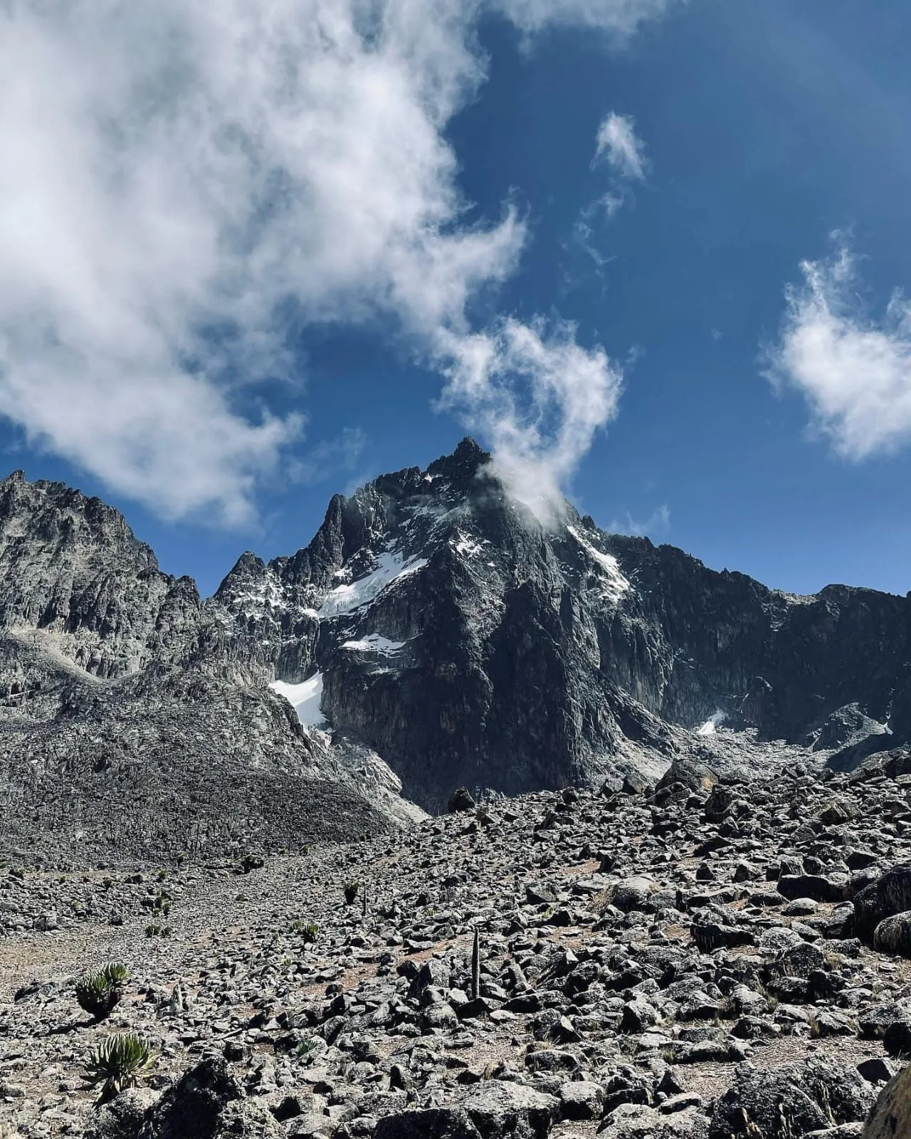
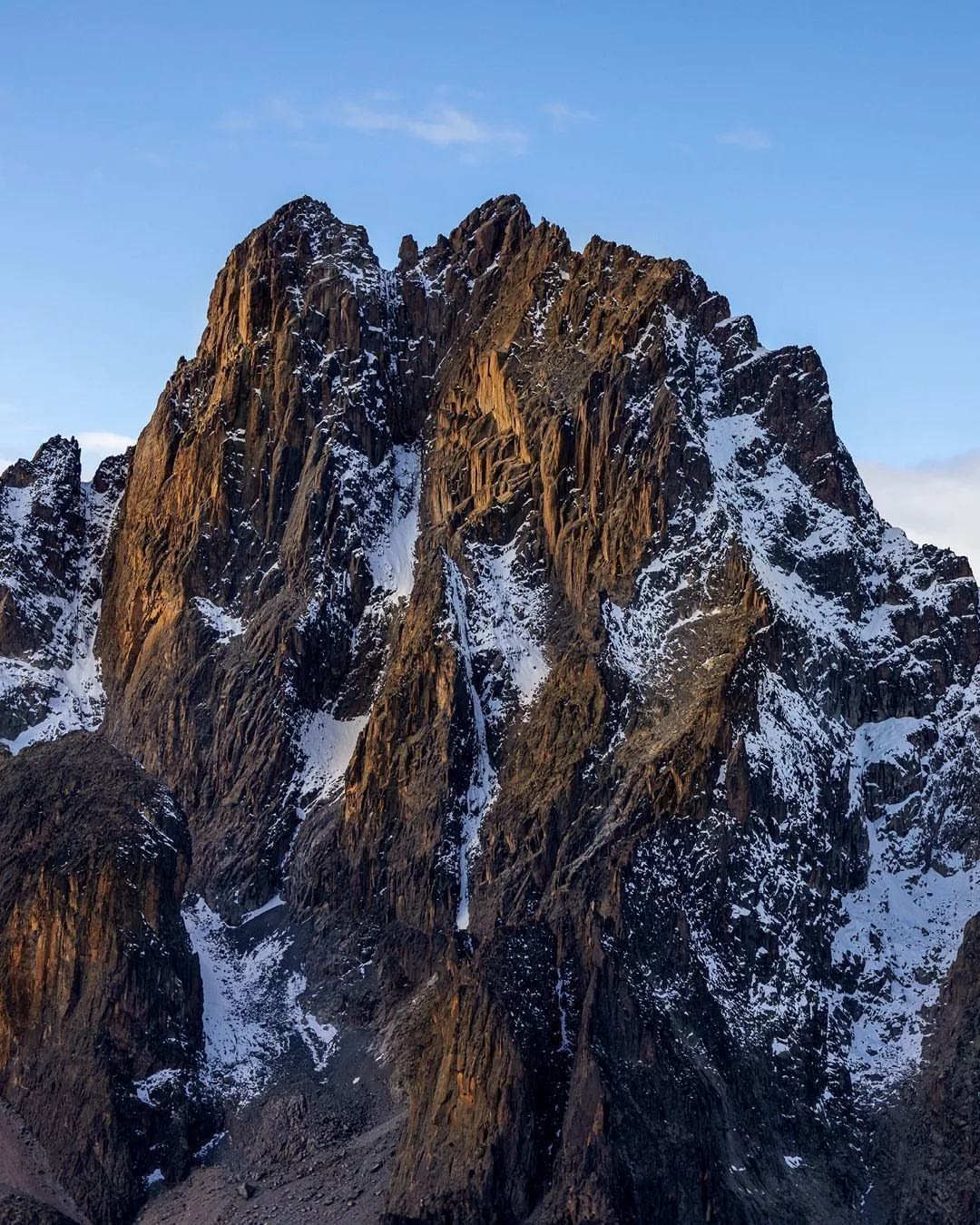
Zone Five — The Nival Zone (4,500m–5,199m) Rock, Ice and the Remnant Glaciers | Batian | Nelion | Point Lenana | The Summit Above 4,500 metres, most vegetation disappears. The zone is dominated by the ancient black volcanic rock of the original plug, interspersed with the remaining fragments of the glaciers that once covered the summit zone completely.
Wildlife
"Completely deteriorated and not for the faint-hearted." The reward for those who accept it: the visual journey through the mountain's forest zones and the specific sense of earned arrival at the cabin door. THE MOUNTAIN HUTS — Essential and Honest The Kenya Wildlife Service operates and maintains a series of mountain huts along the three main routes.

Wildlife
The Honest Answer to the Most Important Question The Short Answer: Most reasonably fit adults can reach Point Lenana (4,985m) the trekking summit with proper preparation, a good guide team, sufficient days and the right mental approach. Batian (5,199m) and Nelion (5,188m) require technical rock-climbing skills that most guests do not have without specific training.

Wildlife
Technical Climbing for Batian/Nelion: Requires documented rock-climbing experience, a qualified IFMGA-certified mountain guide, full technical equipment and specific physical and psychological preparation. Contact Vard Africa for the full assessment and programme design for technical summit clients.

Wildlife
The ITCZ (Intertropical Convergence Zone) is far to the south; rainfall is at its minimum; mornings are clear and cold; the summit visibility is exceptional. Daytime temperatures at lower elevations reach 24–28°C; summit nights drop to -10°C or below. Why climb now: Maximum probability of clear summit views. The Laikipia wildlife below is in excellent condition.

Wildlife
Vard Africa Recommendation: ★★ — For experienced trekkers only PRIME SEASON 2: JULY–SEPTEMBER Long Dry Season | High Season | Best Wildlife | Ideal Climbing July through September is the peak climbing season — the mountain's finest sustained dry period, coinciding with the Kenya safari high season (the Maasai Mara wildebeest migration, school holidays).

Wildlife
The result is fly fishing on the equator at altitudes between 2,000 and 3,500 metres "rugged, beautiful, filled with wildlife, and dare I say pioneering" in the assessment of one of Kenya's most experienced fly fishing guides.
Wildlife
The specific combination: crystal mountain water, wild rainbow and brown trout, buffalo grazing below on the moorland, elephant in the bamboo forest above and the peaks of Mount Kenya rising overhead. This does not exist anywhere else in the world.
Wildlife
"Be prepared as the rainbows in this lake can exceed 8 lbs." Best flies: Dry flies on the shallow edge (Adams, elk hair caddis); weighted zebra midge for the deeper eastern sections; streamer (Viva or leech pattern) for large fish. Access: Rutundu Log Cabins (2-hour hike); no boat; shore and wading fishing.
Wildlife
The Specific Landscape: The lower Sirimon passes through yellowwood forest (Podocarpus latifolius) ancient trees of considerable stature whose open canopy produces a different quality of light from the dense bamboo and camphor forest of the other approaches. Abundant wildlife in this section: elephant, buffalo and colobus monkey are regularly encountered.
Wildlife
THE BURGURET ROUTE The Wilderness Route | For Those Who Want Mount Kenya to Themselves | No Huts | No Other Trekkers | Elephant-Country Camping | The Most Remote Experience on the Mountain Character: The Burguret Route is for a specific kind of guest one for whom the value of a mountain experience is directly proportional to its wildness and

Wildlife
The guides navigate by knowledge and by the game trails that elephant and buffalo have created through the dense bamboo. "Your guide will often be hacking a clear trail as you pass." The guides are accurate about this.

Wildlife
Duration: approximately 6–8 hours. First major encounters with giant lobelias and groundsels. Arrival at Shipton's: Batian and Nelion directly overhead. Acclimatisation walk recommended — a 1–2 hour walk above camp to Simba Col direction, then return, before dinner and early sleep. Distance: approximately 11km. Altitude gain: approximately 800m.

Wildlife
✓ Day 2 — Extended Chogoria ascent: Bandas to Lake Ellis (3,600m) A slower ascent day spending the full day at Lake Ellis for fishing, wildlife observation and the specific pleasure of an alpine lake afternoon before moving to the overnight camp. Maximum engagement with the landscape before the summit pressure of Day 3.
Wildlife
ITINERARY 8 — BURGURET–CHOGORIA TRAVERSE: 6 DAYS The Ultimate Wilderness Experience | No Other Trekkers | Elephant in the Bamboo | Wild Camping | For Experienced Trekkers Only Profile: The most remote and most specifically wild version of the Mount Kenya experience reserved for guests who have prior mountain experience and who specifically choose the hardest, least-travelled, most genuinely wilderness
Wildlife
Elephant and buffalo common in this zone maintain close contact with guides. Wild camp: tents in the bamboo forest. The specific experience: lying in the tent at night, the bamboo above, the sounds of elephant in the darkness. Distance: 10km. Duration: 4 hours.

Wildlife
Batian (5,199m) and Nelion (5,188m) the technical summits do require documented rock-climbing experience and a certified mountain guide. Approximately only 50 people summit Batian per year. ✓ Q: How fit do I need to be? You need to be able to walk 6–8 hours per day on uneven terrain for 4–6 consecutive days.
Wildlife
There is no formal minimum, but Vard Africa recommends a practical minimum of 10 years for Point Lenana attempts, with case-by- case assessment of the specific child's fitness and experience. Children below 10 are well served by the lower forest and moorland zones excellent wildlife encounters, botanical interest and physical challenge without the altitude risk.
When to Go
Month-by-month context, weather, light, rainfall, wildlife visibility, and the best seasonal windows.
When to Go
This has been destroyed by man." The local communities around the mountain's base are already experiencing the consequences: water levels in the Ngare Ngare River have dropped by 30% in a decade. 66% of residents along the Naro Moru River report reduced downstream flow. Rivers that ran year-round in their grandparents' childhood now run dry in the dry season.
When to Go
Unlike Kilimanjaro, where the debate has historically focused on deforestation of the lower slopes as much as temperature, Mount Kenya's glacier loss is directly and primarily attributed to human-induced climate change and global greenhouse gas emissions. The mountain's glaciers are a direct, visible, measurable consequence of what is happening globally to the atmosphere.
When to Go
valley the glacier once filled entirely is to witness one of the most specifically urgent and most specifically visible manifestations of climate change available to any traveller anywhere in the world.

When to Go
The valley that the Lewis once filled is now dry mud and moraine. The white summit that the Kikuyu called Kirinyaga place of brightness is largely brown rock. To visit the mountain in 2026 is to see something that will be gone within a few years.
When to Go
The forest receives up to 2,500mm of rainfall annually on the windward eastern slopes the density of the canopy and the constant moisture producing the specific atmosphere of a highland equatorial forest. The approach through the forest is a safari in itself before the climb has properly begun.
When to Go
The plant has evolved a specific biological adaptation to the conditions at 4,000 metres on the equator: the leaves fold inward at night, trapping warm air around the growing tip, preventing frost damage. The folded leaves trap water, creating a microclimate of warmth inside the plant while the surrounding air drops below freezing.
When to Go
This mechanism nocturnal insulation is unique in the plant kingdom. Giant groundsel (Dendrosenecio keniodendron): a tree-like composite plant growing to 10 metres, the trunk formed by accumulated dead leaf bases of decades of growth, the canopy a rosette of large leaves arranged to channel rainwater toward the root system. These plants live for 40– 60 years.

When to Go
The Lewis Glacier, now just two small blocks of ice in a valley they once filled entirely, is visible on the approach from the northwest. The moraines the ridges of rock debris left by the glacier's former extent are visible on every side, marking where the ice was and how far it has retreated.
When to Go
Dinners: Three-course camp dinners prepared on the mountain with considerable skill given the constraints of altitude cooking. A typical dinner programme: soup (tomato, pumpkin, lentil warming, substantial); main course of pasta, rice dishes, stew or ugali with protein (beef, chicken or vegetarian options); simple dessert.
When to Go
The standard prevention: ascend slowly, drink 3–4 litres of water daily above 3,000m, never ascend with symptoms, always descend if symptoms worsen. The golden rule of altitude: if in doubt, go down. Vard Africa's guides are trained in altitude sickness recognition and response.
When to Go
THE WEATHER, SEASONS AND BEST TIMES TO CLIMB Understanding the weather on Mount Kenya is essential because the mountain creates its own micro-climates and does not simply follow Kenya's standard seasonal patterns. The same day that is clear and warm in Nanyuki below can produce cloud, rain and cold above 3,500 metres.
When to Go
The Mountain's Daily Weather Pattern: Mount Kenya operates on a specific daily cycle throughout the year that is largely independent of the season: Dawn to mid-morning: Clear, cold and calm. The best conditions. The summit views are at their finest in this window. Game drives and summit pushes both benefit from the early start.

When to Go
Late morning to early afternoon: Clouds begin to form over the western slopes as anabatic winds carry moist air from Lake Victoria upward. By 10am–11am the summit peaks are often obscured. Afternoon: Cloud coverage increases, typically bringing rain or mist above 3,000 metres. At lower elevations, the rain is generally limited. Above 4,000 metres, afternoon cloud is reliable.
When to Go
THE FOUR SEASONS — Month by Month PRIME SEASON 1: JANUARY–FEBRUARY Short Dry Season | Best Clarity | Warm Days | Perfect Summit Conditions January and February are the finest months for clear summit views and stable climbing conditions.
When to Go
The combination of summit and safari in this period is the best available. Fewer trekkers than July–August. Vard Africa Recommendation: ★★★★★ — Optimal SHOULDER SEASON: MARCH (first two weeks) Transition | Still Largely Dry | Increasing Cloud The first two weeks of March retain much of January-February's dryness. From mid-March, the transition to long rains begins.
When to Go
Vard Africa Recommendation: ★★★★ — Very good LONG RAINS: MID-MARCH TO JUNE Half the Year's Rainfall | Muddy Trails | Dense Vegetation | Not Recommended for First-Timers The long rains bring approximately half of the annual rainfall in this period — consistent daily rain, typically in the afternoon and evening on the lower slopes, throughout the day above 3,000 metres.
When to Go
The upside: The forest is intensely green and lush. Bird life is at its most active. The mountain is quieter. The specific beauty of the Afro-alpine plants in the mist is genuinely extraordinary. Adventurous, experienced trekkers who do not need summit clarity find the long rains season rewarding.
When to Go
SHORT RAINS: OCTOBER TO EARLY DECEMBER Third of Annual Rainfall | Sporadic Rather Than Daily | Trekking Possible The short rains are less severe and less predictable than the long rains "the short rains generally only provide sporadic daily rain" rather than the consistent daily downpours of March to June. Experienced trekkers can still climb successfully.
When to Go
The weather window within each day remains broadly predictable (clear mornings, possible afternoon rain). The mountain is quiet. Vard Africa Recommendation: ★★★ — Possible with appropriate preparation and experience FESTIVE/TRANSITION: DECEMBER TO MID-JANUARY Short Dry Transition | Christmas Trekking | Cold Nights, Warm Days December to mid-January sees the return of drier conditions.

When to Go
From this single introduction, the fish spread naturally through the interconnected highland drainage systems of Mount Kenya and the Aberdares, and were subsequently stocked in additional rivers and the high-altitude crater lakes.

When to Go
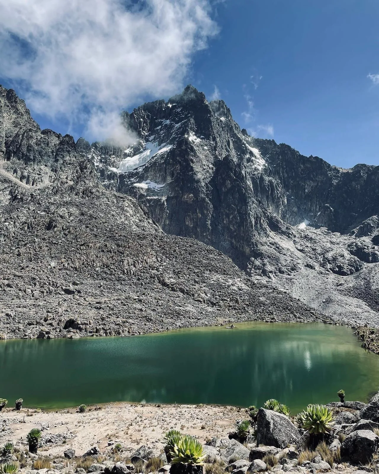
Lake Rutundu (Northern slopes, 3,100m): A volcanic crater lake of exceptional clarity adjacent to the Rutundu Log Cabins. Rainbow trout growing to record sizes in pristine crater water. Fished from the cabin's rowing boat (included in the stay) or from the shore. The shallow sections yield excellent dry-fly sight fishing; the deeper sections respond to nymphs and small streamers.
When to Go
The north-western shallow edge: exceptional sight fishing with dry flies, the rainbow trout clearly visible through the water, their approach and rejection of individual fly patterns readable in detail from the bank.

When to Go
Lake Ellis (Eastern slopes, 3,600m): Eastern side of the mountain above the Chogoria approach large rainbow trout with the specific character of fish that see few anglers. Among the most productive lake fishing on the mountain. Access: Via Chogoria Gate; 4WD to road head; 45 minutes on foot.
When to Go
The Naro Moru River (Western slopes, 2,000m+): Stocked three or four times per year by the Naro Moru River Lodge — rainbow and brown trout; the most accessible fishing on the mountain. Government Trout Licence plus lodge fishing permit required. The lodge kitchen will cook your catch.
When to Go
THE SIRIMON ROUTE The Best First-Timer Route | Gradual Ascent | Highest Success Rate | Driest Conditions | Old Moses and Shipton's Camps Character: The Sirimon Route approaches from the northwest the driest side of the mountain, with lower annual rainfall, more consistent clear mornings and the specific dryness that makes the forest more navigable and the moorland more accessible

When to Go
The specific features that set it apart: Lake Ellis (3,600m): The first significant high-altitude lake, a moorland basin of extraordinary clarity with rainbow trout growing to 8+ lbs. The fishing here occupies additional days for anglers who discover they cannot leave.
When to Go
THE NARO MORU ROUTE The Fastest Route | The Vertical Bog | The Most Direct | For Experienced Trekkers with Limited Time Character: The Naro Moru Route approaches from the west historically the most popular route on the mountain (now surpassed by the Sirimon), and still the fastest route to the summit for guests with genuine time constraints and appropriate
When to Go
The Vertical Bog: This section between the Met Station and the upper moorland is the Naro Moru's defining challenge and the primary reason Vard Africa is careful about recommending it to guests without prior mountain experience. The terrain is steep, permanently waterlogged and unavoidable. In wet conditions it is genuinely severe.
When to Go
Who It Is Right For: Experienced trekkers who have prior altitude experience above 3,000m; guests with genuine and immovable time constraints; fit guests who want the challenge of the more demanding route. Not recommended as a first-time Mount Kenya route.
When to Go
This gives the maximum engagement with the Chogoria landscape at the cost of the traverse experience. This itinerary suits guests who: specifically love the Chogoria landscape and want to see it in both directions; are combining with Nithi River fishing and want the maximum fishing time; or have logistical constraints that require return to Chogoria town.

When to Go
And when you see what remains of the Lewis Glacier two small blocks of grey ice in a valley they once filled entirely, the moraine ridges showing you where the ice was and how far it has retreated you feel that too, in a specific way that no photograph or report communicates.
When to Go
You are standing in front of climate change at 4,900 metres on the equator. The man next to you, the guide who has been climbing this mountain for 25 years, says: "It was very beautiful." Past tense. The mountain is the reason to come to Kenya beyond the game drive. It is the physical foundation of the landscape.
In Detail
The deeper regional story: conservancies, private ranches, reserves, geography, access points, and how the destination fits together.

In Detail
When the Naro Moru guide Lawrence Gitonga who has climbed the mountain for 35 years describes the Lewis Glacier as he first saw it, his language is of fear: "I was terrified of the hulking white mass." When he describes it today: "It's so small and sad.
In Detail
What Is Causing This: The scientific consensus is clear. The primary driver is atmospheric drying reduced cloud cover, reduced snowfall, reduced albedo driven by rising global temperatures. The mountain's position on the equator makes it acutely sensitive to changes in moisture patterns.
In Detail
The generation of guests currently climbing to Point Lenana may be the last who see ice on Mount Kenya at all. The generation after them will arrive to a mountain whose name still carries the memory of glaciers, but whose summit no longer does. This is not a reason to avoid the mountain.
In Detail
The Afro-alpine zone of Mount Kenya contains plants that look designed for another planet: giant lobelias and giant groundsels evolved in total geographic isolation, found nowhere else on Earth, adapted to conditions equatorial position, extreme altitude, frost every night, intense sun every day that no other ecosystem on Earth combines.

In Detail
The view from Point Lenana at dawn the Laikipia plateau below to the west, the Samburu lowlands to the north, the Indian Ocean shimmer to the east on the clearest mornings, Kilimanjaro's silhouette on the southern horizon at over 300 kilometres distance is the same landscape that guests have been observing from safari vehicles all week.
In Detail
✓ Seven — The Completion of the Landscape: Guests who have spent a week on safari looking at the mountain from the plains describe the summit view as the moment when the entire Kenya landscape became comprehensible simultaneously.

In Detail
Mount Kenya stands precisely on the equator at approximately 0° latitude, 200 kilometres north of Nairobi in central Kenya's highland zone, rising from a plateau that lies between 1,600 and 2,000 metres above sea level to its summit at 5,199 metres.

In Detail
The centre of the Laikipia safari circuit. Naro Moru (West — 1,950m above sea level): The traditional starting point for the Naro Moru Route, 40 kilometres south of Nanyuki on the A2 highway. The Naro Moru River Lodge is the primary climbing base on the western side.
In Detail
Chogoria (East — 1,600m above sea level): The gateway to the eastern approach, 185 kilometres from Nairobi via the A2 highway north, then east. The most scenic approach to the mountain; the starting point of the finest trekking route.
In Detail
And replacing both, in isolated colonies and then in extraordinary concentration, appear the plants that have made the mountain world-famous in botanical circles and that leave every trekker reaching for inadequate words.

In Detail
The Afro-alpine zone contains the mountain's glacial lakes: Lake Michaelson, Lake Alice, Lake Rutundu, Lake Ellis crystal-clear, cold, oxygen- rich bodies of water in volcanic rock basins that sustain the trout populations the fly-fishing programme depends on.
In Detail
The Gorges Valley one of the most spectacular single landscape features in East Africa is a glacially carved trough whose walls rise 400 metres on each side, the floor carrying the Nithi River and its wild brown trout toward the lower mountain.
In Detail
Point Lenana at dawn: the summit cross, the 360-degree panorama, the shadow of the mountain extending westward across the Laikipia plateau to the Aberdare Range. On the clearest mornings: Kilimanjaro visible on the southern horizon. The Indian Ocean discernible as a shimmer to the east.
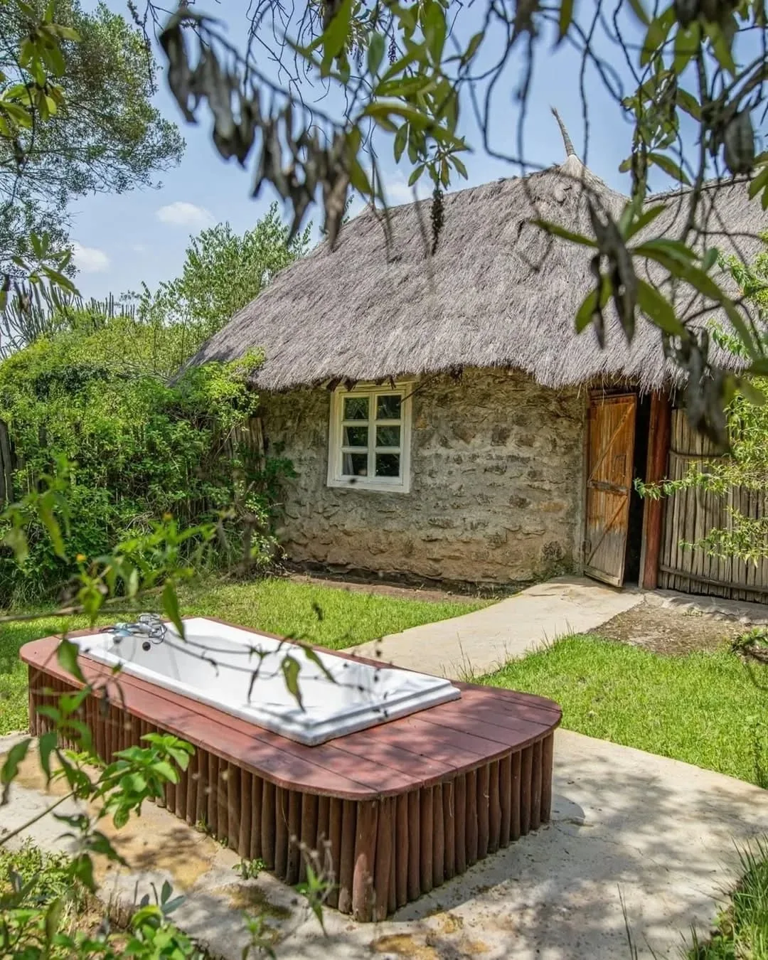
In Detail
They are built in the Alaskan log cabin tradition using large cedar logs harvested from the surrounding forest, the gaps between the logs filled with moss that serves as natural insulation against the cold that 3,100 metres on the equator produces every night.

In Detail
They will cook your trout, set the table on the verandah and make the morning coffee before the sunbird arrives. The Scarlet-Tufted Malachite Sunbird: This specific bird — found only above 3,000 metres on East and Central African mountains, drawn to the giant lobelia flowers adjacent to the cabin — appears at the verandah breakfast table most mornings.
In Detail
NANYUKI-AREA LODGES — The Vard Africa-Recommended Base For all Vard Africa clients, the preferred staging base before and after the mountain is Olepangi Farm in Timau 30 minutes from the Sirimon Gate, at 1,950 metres above sea level, providing natural pre-climb acclimatisation while guests stay in Elizabeth and Clinton's farm environment.
In Detail
As described in the Laikipia Ecosystem guide, Olepangi is the most personally hosted highland farmhouse in the Nanyuki area. The sequence Vard Africa recommends: 2 nights at Olepangi (acclimatisation and preparation) → Sirimon Gate climb → return to Olepangi for 1 night's recovery before continuing the safari or departing.

In Detail
The Naro Moru River Lodge serves as the primary base for western approach climbers a historic mountaineering lodge with equipment hire, guide services, porter coordination and the Naro Moru River trout fishing. WHAT ARE THE CULINARY DINING OPTIONS ?
In Detail
The cook is not an afterthought; on the mountain, where the body is working at altitude, where energy expenditure is high and where warmth and nutrition are the foundations of summit success, the cook is one of the most important members of the expedition.

In Detail
The standard menu programme: Breakfasts: Hot porridge with honey; eggs in multiple preparations (scrambled, omelette, boiled); toast with jam and peanut butter; fresh fruit where available; tea, coffee and hot chocolate. The mountain breakfast is eaten early typically 5am–6am on summit and pre-summit days and is designed to be warm, substantial and easily digestible before significant physical exertion.
In Detail
Packed Lunches: On the mountain days between camps, lunch is a packed meal carried in the daypack: sandwiches with substantial fillings (cheese, cold meat, peanut butter); energy bars and biscuits; fruit; sweet snacks for quick energy. The quality of the packed lunch is often the difference between an energetic afternoon and an exhausted one.
In Detail
The best mountain cooks in Kenya and Vard Africa uses the best produce dinners that guests describe with genuine surprise and genuine gratitude. Snacks and Hydration: The critical addition. At altitude, hydration is the single most important factor in acclimatisation and summit success. Each guest should be drinking 3–4 litres of water daily above 3,000 metres.

In Detail
Vard Africa's mountain teams ensure water is filtered and available continuously. Snacks energy bars, nuts, dried fruit, chocolate are provided continuously throughout the climbing days. The Rutundu Self-Catering: At Rutundu Log Cabins, the self-catering arrangement is managed entirely by Vard Africa as a complete logistics package.
In Detail
Vard Africa Recommendation: ★★★★ — Good, particularly early January Temperature Reference Table (Approximate): Altitude Daytime High Night Low 1,950m (Nanyuki base) 22–28°C 10–14°C 3,000m (Lower mountain) 15–20°C 4–8°C 3,400m (Old Moses/Bandas) 10–16°C 0–4°C 4,200m (Shipton's/MacKinder's) 6–12°C -5 to -8°C 4,985m (Point Lenana summit) -2 to 5°C -10 to -15°C These are approximate figures.

In Detail
MOUNT KENYA FLY FISHING EXPEDITIONS 120 Years of Wild Trout | 40 Rivers and High-Altitude Lakes | The Most Unusual Fishing in Africa The History: In 1905, the British colonial explorer and traveller Ewart Grogan who had walked the length of Africa from Cape to Cairo between 1898 and 1900, the first person known to have done so introduced the
In Detail
More than 120 years later, these trout are fully wild reproducing naturally in streams no stocking programme has touched in decades, feeding on the aquatic insects of highland rivers, growing in cold oxygen-rich water to sizes that reflect their extraordinary environment.
In Detail
The Waters — Where to Fish The Nithi River (Chogoria side, 3,500m–3,950m): "The Nithi is probably my favourite river to fly fish in Kenya." Kenya's leading fly fishing guide. The definitive Mount Kenya river the finest brown trout water in the Afro-alpine zone.
In Detail
The Nithi descends from the high alpine zone through the Gorges Valley's spectacular 400-metre walls before emerging through the moorland south of Chogoria. The water is extraordinarily clear, the river wide enough for casting, the brown trout wild and selective.
In Detail
The specific combination: the mountain peaks above, the Gorges Valley walls on either side, buffalo grazing on the moorland margins, and the specific rhythm of wild brown trout rising in the pools at dusk. Best flies: Adams dry fly; tungsten hare's ear nymph.
In Detail
offices or Naro Moru River Lodge • Park fishing permit: required for all water inside Mount Kenya National Park The Kenya-Specific Flies: Two fly patterns were developed specifically for Kenya's highland trout: the Kenya Bug and the Mrs.
In Detail
For guests who want the combination of fishing and summit: ascend via Chogoria (fishing Lake Ellis and the Nithi en route), summit Point Lenana, descend via Sirimon. 6–7 days total.
In Detail
Above the forest, the route opens into the heath zone and then the wide, open moorland of the Liki North Valley one of the most beautiful moorland landscapes on the mountain, surrounded by heather and tussock grass with the summit peaks visible ahead.

In Detail
Vivienne Falls: A spectacular waterfall on the descent from Lake Ellis toward the Gorges Valley visible from the trail above before the valley floor is reached. The Gorges Valley: The most dramatic single landscape feature on any Mount Kenya route.

In Detail
Lake Michaelson (3,950m): At the head of the Gorges Valley a glacial lake in a dramatic amphitheatre of cliffs, the summit peaks directly above, the Gorges Valley visible below. The campsite here the night before the final approach to Point Lenana is the finest single camping position on the mountain. The cold is significant at 3,950m. The views are total.

In Detail
The route is longer than the Sirimon and Naro Moru, requires 4WD vehicle support on the lower forest section and demands more days for full appreciation. The Gorges Valley descent requires careful footing. The Lake Michaelson to Simba Tarn section is the steepest sustained grade on the standard trekking routes. Duration: 4–7 days depending on the itinerary (see Chapter XIII).
In Detail
Combining with Sirimon Descent: The Naro Moru-Sirimon combination is the second most popular traverse on the mountain — ascending via Naro Moru's direct line and descending via the Sirimon's gradual western route. This adds the variety of two different approaches while managing the descent's physical demands on the more forgiving Sirimon side. Duration: 4–5 days recommended (see Chapter XIII).
In Detail
Of Mount Kenya's four main routes, the Burguret is the one that the mountain has not yet entirely tamed. The History: The Burguret was pioneered during the British colonial era and then abandoned for many years the track becoming overgrown, the route returning to the forest and the animals that used it before people.
In Detail
A specific footnote in the route's history: when Felice Benuzzi, Giovanni Balletto and Vincenzo Barsotti escaped from the British PoW camp at Nanyuki in January 1943 and climbed Mount Kenya a story told in Benuzzi's extraordinary memoir No Picnic on Mount Kenya, one of the finest pieces of mountain literature in the English language they climbed via a route remarkably
In Detail
The Specific Character: The Burguret begins at Mountain Rock Lodge (1,950m) near Nanyuki or at the Gathiuru Forest Station and from the first day it is a different mountain from any other approach. There is no defined trail in the lower section.
In Detail
Highland Castle (3,700m) — the second overnight: open moorland, the mountain opening up, the summit peaks visible for the first time. The name implies grandeur; the reality is a wild campsite on exposed moorland with exceptional views.

In Detail
Descent from Point Lenana south to Hall Tarns and then to Lake Michaelson (3,950m) via the upper Chogoria Valley. This long descent crosses the mountain through the Gorges Valley's upper section and provides the first views of the spectacular Chogoria landscape. Overnight at Lake Michaelson. Duration: 12– 14 hours total. Distance: approximately 18km. Significant altitude gain and loss.

In Detail
The ascent provides the maximum scenic impact (Gorges Valley, Vivienne Falls, Lake Ellis) before the commitment of the summit push; the descent via Sirimon is the most comfortable and most gradual.
In Detail
✓ Day 1 — Nairobi/Nanyuki to Chogoria Bandas (3,000m) Drive from Nanyuki south to Chogoria town (approximately 90 minutes) then 4WD through the bamboo forest to the Meru Mount Kenya Bandas at 3,000m. Afternoon: first exploration and possible Nithi River fishing for fly fishing clients. Overnight in bandas. Altitude: 3,000m.

In Detail
✓ Day 2 — Chogoria Bandas (3,000m) to Lake Michaelson (3,950m) via Gorges Valley The most spectacular single day on the mountain. From the bandas, the trail climbs through moorland to Lake Ellis (3,600m) excellent fly fishing for guests with rods.

In Detail
Continuing past Lake Ellis, the route descends into the Gorges Valley — the walls rising on each side, the Nithi River below, Vivienne Falls audible before it is visible. The valley floor leads to the Lake Michaelson campsite at 3,950m in its glacial amphitheatre. Duration: 7–8 hours. Distance: approximately 12km. Altitude gain: approximately 950m.

In Detail
✓ Day 3 — Summit Day: Lake Michaelson (3,950m) to Point Lenana (4,985m) and Shipton's Camp Departure at 2am from Lake Michaelson. Ascent via Simba Tarn (4,620m) to Point Lenana approximately 4–5 hours from camp. Summit at dawn. Descent northwest to Hall Tarns and Shipton's Camp (4,200m) for rest, hot food and recovery. Overnight at Shipton's. Duration: 12–14 hours total.
In Detail
Walk through dense forest to the Met Station at 3,050m a 4–5 hour walk on a good vehicle track through montane forest and bamboo. First overnight at Met Station. Altitude: 3,050m. ✓ Day 2 — Met Station (3,050m) to MacKinder's Camp (4,200m) via the Vertical Bog The defining day of the Naro Moru Route.
In Detail
Descent to Shipton's Camp on the Sirimon side crossing the mountain's summit zone. Overnight Shipton's. ✓ Day 4 — Shipton's Camp to Sirimon Gate Descent via the Liki North Valley to Old Moses Camp and Sirimon Gate. Vehicle transfer.
In Detail
This is the itinerary Vard Africa recommends most strongly for guests for whom the journey matters as much as the summit. ✓ Day 1: Drive and ascent to Chogoria Bandas (3,000m). Afternoon Nithi River fishing.

In Detail
✓ Day 1: Chogoria town to Bandas (3,000m). Afternoon Nithi River fishing. ✓ Day 2: Bandas to Lake Ellis (3,600m). Full day's trout fishing at Lake Ellis. ✓ Day 3: Lake Ellis (3,600m) to Lake Michaelson (3,950m) via Gorges Valley. The full day in the Valley. ✓ Day 4: Lake Michaelson to Simba Tarn (4,620m). Acclimatisation at altitude.

In Detail
This is the route for guests who believe the finest safari is the one with nobody else on it. ✓ Day 1 — Nairobi to Mountain Rock Lodge (1,950m) Drive from Nairobi (or Nanyuki) to Mountain Rock Lodge at 1,950m on the western slopes. Afternoon acclimatisation walk in the local forest. Briefing with guide team, equipment check.
In Detail
Park fees arranged at Naro Moru Gate (there is no Burguret Gate). Overnight at Mountain Rock Lodge. ✓ Day 2 — Mountain Rock Lodge to Giant Bamboo Camp (2,600m) Drive to Gathiuru Forest Station; brief through the Mau Mau caves. Begin the 10km, 4-hour ascent through towering bamboo to Giant Bamboo Camp at 2,600m.
In Detail
Distance: approximately 12km. Altitude gain: 1,100m. ✓ Day 4 — Highland Castle (3,700m) to Shipton's Camp (4,200m) The connection from the Burguret's high camp to the standard mountain network. Through open moorland and the upper Afro-alpine zone to Shipton's Camp. Duration: 4–5 hours.

In Detail
✓ Day 6 — Nithi Camp to Chogoria Gate and Out Descent through the Gorges Valley past Vivienne Falls and Lake Ellis to the Chogoria forest bandas. 4WD to Chogoria town.
In Detail
✓ Q: What is altitude sickness and how do I avoid it? Acute Mountain Sickness (AMS) affects approximately 75% of people ascending above 3,000m without adequate acclimatisation. Symptoms: headache, nausea, fatigue, loss of appetite, difficulty sleeping. Prevention: ascend slowly (the "never ascend with symptoms" rule); drink 3–4 litres of water daily; choose longer itineraries; never push through worsening symptoms.

In Detail
✓ Q: Can I fish and summit in the same trip? Absolutely and this is one of the most specifically rewarding combinations Vard Africa curates. The 5-day Chogoria–Sirimon traverse naturally incorporates Nithi River and Lake Ellis fishing during the ascent. The 6-day version allows more dedicated fishing time.
In Detail
Guides require their own park certification. Fly fishing within the park requires a Government Trout Licence plus a National Park fishing permit. Vard Africa coordinates all permit logistics as part of the mountain programme. A VARD AFRICA FINAL NOTE ON MOUNT KENYA There is a specific kind of knowledge that a mountain forces on you that nothing else does.
In Detail
It is not intellectual knowledge not the knowledge that glaciers are melting or that the Lewis Glacier has lost 90% of its volume since 1934 or that Mount Kenya's ice will be gone before 2030. You could acquire that knowledge from reading this chapter. The knowledge the mountain forces is physical.
In Detail
It is the source of every river. It carries the name of the country. And it is disappearing. Come while it is still here to see. With the deepest respect for this mountain and its communities.
Experiences
Game drives, walks, riding, cultural immersion, conservation activities, scenic flights, and special interests.
Experiences
It is the most specific and most urgent reason to go. WHAT ARE THESE EXPERIENCES ABOUT? The Mount Kenya experience is not a single thing. It is an accumulation of completely different encounters each one available nowhere else, each one adding a dimension to the Kenya journey that the safari alone cannot provide. ✓ It is about altitude.

Experiences
Going up ascending through five distinct ecological worlds in three to six days of walking, each world separated from the next by temperature and biology, until the summit zone of rock and ice is reached at almost five thousand metres. The mountain forces altitude.

Experiences
Walking through a field of 6-metre lobelias in the morning light is an experience that stays with guests permanently. ✓ It is about the glaciers while they exist. The specific opportunity closing fast to stand beside ice that has been on this mountain for thousands of years and is now in its final decade.
Experiences
WHY IS THIS A SPECIAL ADD-ON FOR ADVENTURERS? The guests for whom the Mount Kenya experience is specifically and powerfully right are guests who have reached a specific point in their safari life: they have done the game drives. They have mastered the binoculars. They know how to read the landscape from a vehicle.

Experiences
And they are ready for something that uses their bodies rather than their eyes. Seven specific reasons the mountain is the finest adventure add-on in the Kenya portfolio: ✓ One — The Vertical Safari: The ascent crosses more distinct ecosystems in three days than most Kenya safaris encounter in a week.
Experiences
The conservancies below, the rivers they have crossed, the distant mountains they have been told are there all visible at once from 4,985 metres. The safari gave them the ground-level experience. The mountain gives it its context. WHERE IS MOUNT KENYA?
Experiences
The mountain that frames the safari horizon is the same mountain guests can be climbing the morning after their final game drive. THE FIVE WORLDS OF MOUNT KENYA Altitudinal Zones — What Guests Encounter at Every Stage Mount Kenya does not have one landscape.
Experiences
It has five stacked vertically, each separated from the next by altitude, temperature and the specific ecology that altitude and temperature produce. Understanding these zones is the foundation for understanding what the climb experience actually is.

Experiences
Zone Four — The Afro-Alpine Zone (3,500m–4,500m) Giant Lobelias | Giant Groundsels | The Otherworldly Landscape | The Glacial Lakes | The Gorges Valley This is the zone that makes Mount Kenya genuinely unlike any other mountain experience in the world. The heather reduces and disappears. The tussock grass shortens.

Experiences
Walking through a field of these plants at dawn the lobelias still folded against the night's cold, the groundsels catching the first horizontal light is one of those experiences that guests describe as the single image that stays with them from the entire mountain.

Experiences
Food on the mountain is a specific and important dimension of the Mount Kenya experience one that is often significantly better than guests expect and that contributes meaningfully to the quality of the expedition. The Mountain Catering Standard: Vard Africa partners with professional mountain guiding companies who employ dedicated mountain cooks as part of every team.

Experiences
Guests who walk regularly, who hike at weekends or who maintain general fitness through any sustained aerobic activity swimming, cycling, gym are typically adequately prepared. Prior High-Altitude Experience: Not required for Point Lenana. The acclimatisation programme built into the itinerary (slow ascent, proper days at altitude) is designed to allow guests without prior high-altitude experience to reach the summit safely.
Experiences
Guests who have prior altitude experience above 3,500m do have an advantage in knowing how their bodies respond but it is not a prerequisite. What Stops Most People: Not fitness. Altitude sickness. This is the primary challenge on Mount Kenya, and it is entirely manageable with the right itinerary.
Experiences
The Naro Moru Route's Vertical Bog becomes genuinely treacherous. The Chogoria Route's lower sections become muddy and challenging. The Sirimon and Burguret Routes are manageable for experienced trekkers with appropriate equipment.

Experiences
The Vard Africa Fly Fishing Programme Vard Africa curates the Mount Kenya fly fishing expedition as a complete 3–5 night programme: Helicopter transfer from Nanyuki or from a Laikipia lodge to Rutundu helipad (10–40 minutes depending on origin) → 2–3 nights at Rutundu Log Cabins with guided daily fishing on Lake Rutundu, Lake Alice and the Kazita River → Extension
Experiences
lower section (a distinct and beautiful forest type, absent from the bamboo-dominated alternatives); the open, spacious character of the upper moorland; and the Mackinder's Valley approach to the summit a wide, beautiful alpine valley with the peaks visible ahead for hours of walking.
Experiences
It is, without qualification, the most beautiful route on Mount Kenya and the most beautiful mountain route in East Africa a designation that every experienced Mount Kenya guide, every travel writer who has written about the mountain and every trekker who has done multiple routes confirms with the same conviction.
Experiences
Descending into the Gorges Valley from above the walls appearing around you, the river audible below, the summit peaks framed in the notch ahead is the single most specifically memorable landscape moment in the Mount Kenya trekking experience. No photograph does it justice. Every trekker who passes through it describes it immediately, accurately and with the same inadequate language: extraordinary.
Experiences
This combination provides: • The most beautiful scenery in ascent (Chogoria) • The most comfortable and fastest descent (Sirimon) • A complete traverse of the mountain from east to west • Two completely different ecological experiences in a single itinerary Difficulty: Moderate to challenging.
Experiences
Gaiters and fully waterproofed boots are mandatory; without them the section is impassable. The experienced guides who lead this route know every section of the bog and can navigate the least severe lines through it — but they cannot make it dry or flat.

Experiences
Three prisoners of war, with improvised equipment, climbing Africa's second-highest mountain in mid-summer as an act of defiance and adventure. The mountain accepted them. It accepts all who come to it with sufficient respect and sufficient preparation.
Experiences
From Highland Castle, the route connects to Shipton's Camp (4,200m) on the standard Sirimon/Chogoria network, and the summit attempt proceeds as on any other route. The descent is almost always via the Chogoria Route the combination of the Burguret's wilderness ascent and the Chogoria's spectacular scenery on descent creating the most complete single experience available on the mountain.
Experiences
Practical Requirements: • No official KWS Park Gate on the Burguret; park fees must be paid at the Naro Moru Gate in advance • Full camping equipment there are no huts on this route • An experienced guide who knows the Burguret specifically (not all mountain guides do) • Physical fitness above the standard of the three main routes the
Experiences
For experienced trekkers who have prior mountain experience and who are specifically seeking the most remote and most wild version of the Mount Kenya experience. Not appropriate as a first Mount Kenya climb. Duration: 6 days (Burguret ascent + Chogoria descent is the standard combination).

Experiences
This is the itinerary Vard Africa most frequently recommends for safari clients adding the mountain to a Laikipia or Samburu circuit, as it provides the most complete experience within a tight time frame.
Experiences
✓ Day 3 — Summit Day: Shipton's Camp to Point Lenana (4,985m) and Hall Tarns Departure: 2am–3am. The pre-dawn summit push from Shipton's approximately 3–4 hours to Point Lenana via Simba Col (4,620m). Summit at or before dawn for the full sunrise experience. Time at summit: 30–60 minutes depending on cold tolerance and conditions.

Experiences
✓ Day 4 — Lake Michaelson (3,950m) to Chogoria Gate and Out The most beautiful day's walking descending through the Gorges Valley past Vivienne Falls, through Lake Ellis and the eastern moorland to the Chogoria forest bandas. 4WD vehicle from the bandas to Chogoria town. Duration: 6–8 hours walking plus vehicle transfer. Distance: approximately 15km walking.
Experiences
ITINERARY 2 — CHOGORIA–SIRIMON: 4 DAYS The Classic Traverse in Reverse | Ascending Through the Most Scenic Landscape | The Gorges Valley from Below Profile: The Chogoria–Sirimon direction ascending via the spectacular eastern approach and descending via the comfortable western route is the direction recommended by most specialist Mount Kenya operators as the finest single 4-day experience on the mountain.
Experiences
ITINERARY 3 — NARO MORU–SIRIMON: 4 DAYS For Experienced Trekkers | The Fastest Ascent | The Vertical Bog | Comfortable Sirimon Descent Profile: The Naro Moru–Sirimon combination is the choice for physically fit, experienced trekkers who want to test themselves against the mountain's most demanding standard approach.
Experiences
ITINERARY 4 — SIRIMON–CHOGORIA TRAVERSE (5 DAYS) The Gold Standard for Summit Success | Extra Acclimatisation Day | Higher Success Rate | The Most Complete 5-Day Experience Profile: The 5-day version of the classic Sirimon–Chogoria traverse adding a critical acclimatisation day at Shipton's Camp before the summit push.
Experiences
This is the itinerary that most consistently produces successful summits across the widest range of guest fitness levels. For any guest without prior altitude experience above 3,000m, the 5-day option is strongly preferred over the 4-day. ✓ Days 1–2: As Itinerary 1, Days 1–2 (Sirimon Gate to Shipton's Camp).
Experiences
✓ Day 3 — Acclimatisation Day at Shipton's Camp (4,200m) The most important day of the itinerary. A rest and acclimatisation day at 4,200m not resting entirely but including a 2–3 hour walk to Simba Col (4,620m) and back. This altitude excursion going higher during the day and returning to sleep lower is the single most effective acclimatisation technique available.

Experiences
The specific physiological response: the body produces more red blood cells in response to the altitude exposure; sleeping at 4,200m after the excursion to 4,620m gives the body maximum adaptation time. Success rates on the following morning's summit push increase significantly with this day. ✓ Day 4 — Summit Day and Descent to Lake Michaelson: As Itinerary 1, Day 3.

Experiences
ITINERARY 5 — CHOGORIA–SIRIMON: 5 DAYS The Finest Complete Experience | The Most Recommended | Ascending the Beautiful Side | Extra Day for Fishing or Rest Profile: The 5-day Chogoria–Sirimon traverse with the additional day used for either Nithi River fly fishing at Lake Ellis, or for a leisurely ascent from Chogoria Bandas to Lake Michaelson with maximum time in
Experiences
✓ Day 5 — Shipton's to Sirimon Gate: As Itinerary 2, Day 4. ITINERARY 6 — SIRIMON–CHOGORIA: 6 DAYS Maximum Acclimatisation | Highest Summit Success Rate | For Guests with No Previous Altitude Experience or Those Who Want the Best Possible Chance Profile: The 6-day Sirimon–Chogoria traverse with two acclimatisation opportunities and maximum flexibility.

Experiences
✓ Day 4 — Second Acclimatisation Option: Optional second excursion above Shipton's OR rest day depending on individual response to altitude. Summit push possible from this day if guests are ready early. ✓ Day 5 — Summit and Descent to Lake Michaelson: Summit at dawn; descent to Lake Michaelson overnight.

Experiences
ITINERARY 7 — CHOGORIA–SIRIMON: 6 DAYS (FULL HIKE) The Complete Chogoria Experience | Maximum Time in the Most Beautiful Landscape | All Three Major Lakes | Gorges Valley with Leisure Profile: The most complete single engagement with the Chogoria landscape ascending slowly through Lake Ellis, Lake Michaelson and Simba Tarn, spending maximum time in the Gorges Valley and the Afro-alpine

Experiences
ITINERARY 9 — CHOGORIA–POINT LENANA The Definitive Chogoria Experience | For Guests Who Want Maximum Time on the Scenic Route Profile: An itinerary specifically designed for guests who want to maximise their time on the Chogoria side ascending via Chogoria, spending extra time in the Gorges Valley and at Lake Michaelson, and descending via the same route rather than traversing

Experiences
Structure: 5–6 days ascending and descending Chogoria with 2 nights at Lake Michaelson. Contact Vard Africa for the specific day-by-day programme tailored to the client's fishing and summit priorities. FREQUENTLY ASKED QUESTIONS The Vard Africa Answers ✓ Q: Do I need any mountaineering experience to reach Point Lenana? No.

Experiences
The best preparation: regular walking, hiking or sustained aerobic exercise 6–8 weeks before the climb. Trekking poles are highly recommended for the descent gradients. The specific fitness concern at altitude is cardiovascular the heart and lungs working harder in thinner air. Any sustained aerobic fitness (running, cycling, swimming, gym) prepares you adequately.
Experiences
This is specifically and enthusiastically recommended by Vard Africa. The most natural combinations: Laikipia safari → Olepangi Farm acclimatisation → Mount Kenya summit → continue to Samburu. Or: Samburu → Laikipia → Olepangi/Mount Kenya as the final experience before departing Kenya. The mountain gives the safari its physical context; the safari gives the mountain its landscape context.
Experiences
The two together are the complete Kenya experience. ✓ Q: What permits do I need? All climbers must enter through an official KWS Park Gate and pay National Park entrance fees (approximately USD 35–52 per day for non-residents). Park camping fees (approximately USD 12 per person per night) and hut fees (approximately USD 15–25 per night) apply additionally.

Experiences
You feel the specific, earned quality of the summit moment Point Lenana at 4,985 metres, the sky lightening from black to deep blue to gold, the Laikipia plateau spread below, the same landscape you have been crossing in game drive vehicles becoming, from here, a map rather than a world.
Planning Notes
Access, health, safety, family suitability, minimum stays, routing, airstrips, and the details that make the journey work.
Planning Notes
This is not something that can be planned for "next time." ✓ Four — The Physical Achievement: Point Lenana at 4,985 metres is the highest non-technical summit in East Africa accessible to a fit guest without specialised equipment. The summit is earned. The body accomplished something. The memory is permanent in a way that observation alone however extraordinary is not.

Planning Notes
✓ Six — The Access: 3–4 hours by road from Nairobi. 30–45 minutes from Nanyuki. The mountain is not a detour from the Laikipia safari; it is a direct extension of it. Guests staying at Olepangi Farm, El Karama, Ol Pejeta or any Nanyuki-area lodge are already at the base.

Planning Notes
The mountain is bounded by three gateway towns that serve as the primary access points for the climbing routes: Nanyuki (North/Northwest — 1,950m above sea level): The primary hub for the northern approaches. Staging town for the Sirimon Route. 30 minutes by road to Sirimon Gate. Well-serviced with Dorman's Coffee, The Butcher's Block, Artcaffé, Nanyuki Airport and Nanyuki Cottage Hospital.

Planning Notes
Physical relationship to the Laikipia safari circuit: The mountain is the constant eastern reference point of every day's safari in the Laikipia ecosystem. From Ol Pejeta 20 kilometres to the west of the Sirimon Gate. From El Karama 40 kilometres. From Olepangi Farm 30 kilometres. From Borana and Lewa 50 kilometres.
Planning Notes
They were ancient when the first European explorers saw them. They are alive at altitudes where most plants cannot survive. They look like something from a children's book about prehistoric Earth which is, in the deepest sense, exactly what they are.
Planning Notes
Vard Africa manages all provisioning logistics — packing supplies in Nanyuki, vehicle to the road head and porter coordination for the 15-minute carry from car park to cabin. The resident staff (Jackson, James and Sullivan — named specifically in guest reviews as outstanding) assist with cooking, fire-lighting and guiding.

Planning Notes
From any Laikipia lodge: 20–40 minutes depending on origin. This is the finest arrival — the helicopter approaching over the northern moorland, the lake appearing below, the cabins on its shore and the mountain crags above. Kisima Farm (adjacent) provides polo horse transfers for experienced riders — a 4-hour ride through the moorland.
Planning Notes
By Charter Aircraft (15 minutes from Nanyuki): An airstrip 1.5 kilometres from the cabins accepts light aircraft. Charter from Nanyuki: approximately 10 minutes. From Nairobi Wilson: 50 minutes.

Planning Notes
By 4WD (4–5 hours from Nanyuki — an adventure in itself): The mountain access track is consistently described in guest reviews as one of the most challenging roads in Kenya even in a Land Cruiser.
.webp?v=1779270229)
Planning Notes
Special Dietary Requirements: Vegetarian, vegan, gluten-free and all specific dietary requirements are accommodated with advance notice. The mountain cooks are experienced in adapting the standard menu; Vard Africa provides the mountain team with complete dietary briefing before departure. CAN ANYONE CLIMB MOUNT KENYA?
Planning Notes
The More Complete Answer: Age: There is no upper age limit for attempting Point Lenana. Guests in their late 60s and 70s successfully summit every year. The determining factors are cardiovascular fitness, joint health and the willingness to go slowly. Younger is not necessarily better; experience and patience at altitude matter more than youth.
Planning Notes
Children: Children aged 10 and above with appropriate fitness levels can attempt Point Lenana on the longer itineraries (5–6 days). Children below 10 are best kept to the lower forest and moorland zones rather than the summit attempt. The minimum age for summit attempts should be discussed with Vard Africa on a case-by-case basis.
Planning Notes
Christmas and New Year are popular for family climbs a tradition among Kenyan and expatriate families. Conditions are generally good, though the Christmas period brings the mountain's busiest local traffic.

Planning Notes
Best flies: Adams dry fly for surface; pheasant tail nymph subsurface; small woolly bugger for deeper sections. Access: Rutundu Log Cabins; rowing boat provided. Lake Alice (Northern slopes, 3,530m): Two hours of strenuous hiking above Rutundu a crystal-clear alpine lake set in a volcanic rock bowl.
Planning Notes
The Kazita River (Northern slopes, adjacent to Rutundu): A small, technically demanding stream in a gorge near Rutundu — confined spaces require roll casts and bow-and-arrow presentations. "Small-weighted nymphs in black are best." For advanced fly fishers who want the challenge of tight-quarters technical fishing. Access: From Rutundu Log Cabins.

Planning Notes
The specific technique challenge: roll casts. The vegetation along most mountain rivers is dense enough that overhead casting is often impossible. The proficient roll cast is the essential technique for Mount Kenya river fishing. Bow-and-arrow presentations are required on the Kazita. Lake fishing allows overhead casting but requires precise fly placement to rising or cruising fish.

Planning Notes
Equipment: • Rivers: 2–3 weight rod; tippet to 6lb; large fly box including Adams, elk hair caddis, pheasant tail, hare's ear, tungsten nymphs • Lakes: 4–6 weight rod; floating and intermediate lines; dry flies for surface; streamers for depth • Waders: advisable for river sections; chest waders not required for most positions • Government Trout Licence: obtainable at KWS Nanyuki
Planning Notes
THE CLIMBING ROUTES Four Iconic Paths — Every Character, Every Difficulty, Every Landscape Mount Kenya's routes are the four approaches that between them cover every character the mountain offers — from the most accessible and most gradual to the most remote and most wild.
Planning Notes
The approach to Shipton's Camp passes through increasingly dramatic Afro-alpine vegetation, the giant lobelias and groundsels appearing in their full scale in the last section before the high camp. Difficulty: Moderate. Suitable for guests with general fitness and no prior high-altitude experience on the longer itinerary options.

Planning Notes
THE CHOGORIA ROUTE The Most Scenic Route on Any East African Mountain | Lake Ellis | The Gorges Valley | Lake Michaelson | The Non- Negotiable Traverse Partner Character: The Chogoria Route approaches from the east through the mountain's most botanically rich and most visually spectacular landscape. It is not the fastest route or the most accessible route.
Planning Notes
Its defining features: speed (achievable in 3 days for an experienced, acclimatised trekker); the infamous Vertical Bog (a steep, permanently waterlogged section of moorland that is the most physically challenging section of any standard trekking route); and the most direct line to the summit from the western access.
Planning Notes
THE VARD AFRICA ITINERARY PROGRAMMES Nine Routes and Combinations — With Day-by-Day Detail ITINERARY 1 — SIRIMON–CHOGORIA: 4 DAYS The Efficient Traverse | Ideal for Safari Combination | Highest Success Rate in 4 Days | Two Sides of the Mountain Profile: The classic 4-day Mount Kenya traverse ascending via the Sirimon's gradual western approach and descending via the Chogoria's scenic
Planning Notes
✓ Day 1 — Nairobi/Nanyuki to Old Moses Camp (3,400m) Departure from Nanyuki after breakfast drive to the Sirimon Gate (approximately 30 minutes from Nanyuki), register with KWS and begin the ascent. The day's walk: through yellowwood forest and heath, approximately 5–6 hours to Old Moses Camp at 3,400m. First views of the summit peaks on arrival.
Planning Notes
Hot dinner at the hut. Sleep at 3,400m the first altitude night. Distance: approximately 10km. Altitude gain: approximately 750m. ✓ Day 2 — Old Moses Camp (3,400m) to Shipton's Camp (4,200m) The longest day through the Liki North Valley across open moorland, past the Liki North stream and up through increasingly dramatic Afro-alpine vegetation to Shipton's Camp at 4,200m.
Planning Notes
From the Met Station, the trail climbs steeply through more bamboo and dense vegetation before entering the Vertical Bog the permanently waterlogged, steep section that requires gaiters, good boots and determination. Above the bog, the route opens onto the
Planning Notes
✓ Day 3 — Lake Ellis to Lake Michaelson via the Gorges Valley The Gorges Valley Day, Day 2 but without the pressure of the preceding day's ascent. Arrival at Lake Michaelson in better physical condition and better psychological state for the summit push. ✓ Day 4 — Summit Day: As Itinerary 2, Day 3.
Planning Notes
The Luxury Safari Company's recommendation for guests over 55 or those with specific medical considerations that require extra care at altitude. ✓ Day 1: Drive and ascent to Old Moses Camp (3,400m) via Sirimon Gate. ✓ Day 2: Old Moses to Shipton's Camp (4,200m). ✓ Day 3 — Acclimatisation at Shipton's: Walk to Simba Col (4,620m) and return. Full rest.
Planning Notes
✓ Day 3 — Giant Bamboo Camp (2,600m) to Highland Castle (3,700m) Through montane forest, pencil cedar, podocarpus and then the Hagenia rosewood zone at the moorland edge. The path becomes more defined above the forest. Arrival at Highland Castle open moorland at 3,700m with the summit peaks visible for the first time. Wild camp. Duration: 5–6 hours.
Planning Notes
Arrival at the hut infrastructure of the standard routes — a specific contrast with the previous two wild camp nights. ✓ Day 5 — Summit Day: Shipton's to Point Lenana and Descent to Nithi Camp Pre-dawn summit push. Point Lenana at dawn. Descent east via Hall Tarns into the Chogoria landscape, descending to Nithi Camp on the upper Gorges Valley.

Planning Notes
Point Lenana (4,985m) is the trekking summit accessible to any physically fit adult with a proper guide team and an adequate acclimatisation itinerary. No ropes, no harnesses, no technical climbing skills required. The summit morning involves a steep, cold walk on loose rock and scree, which requires determination and good footwear but no specialized technique.
Planning Notes
Treatment: immediate descent resolves symptoms in virtually all cases. Prescription medication (Diamox/acetazolamide) can assist acclimatisation discuss with your travel physician before departure. AMREF Flying Doctors coverage is mandatory for all Vard Africa mountain clients. ✓ Q: What is the minimum age for the summit?
Planning Notes
✓ Q: What do I need to pack? Clothing layers: Thermal base layers (top and bottom); mid-layer fleece; wind and waterproof outer layer; down jacket for summit night; warm hat, gloves and balaclava; trekking trousers; gaiters (essential for Naro Moru, advisable for all); waterproof socks. Footwear: Broken-in waterproof trekking boots with ankle support; camp sandals or crocs for hut evenings.
Planning Notes
On the Burguret and at wild camping positions, proper Leave No Trace wilderness protocols apply guides carry waste disposal equipment. ✓ Q: What medical resources are available on the mountain? All KWS Ranger Stations (Met Station, MacKinder's, Shipton's, Chogoria and Sirimon Gates, Austrian Hut) have radios for emergency communication.

Planning Notes
Vard Africa's guides carry comprehensive first aid kits including emergency altitude medication. AMREF Flying Doctors can reach the mountain's airstrips (Nanyuki Airport, Rutundu Airstrip) within 30–60 minutes. Nanyuki Cottage Hospital is approximately 30–40 minutes from the Sirimon Gate. Carry travel insurance covering helicopter evacuation and high-altitude mountain rescue. ✓ Q: Can I combine the mountain with a safari?
Mount Kenya National Park, Kenya
Signature Journeys
Each of these journeys is shaped around this landscape — privately guided, personally crafted.
Featured Journey
A highland journey around Mount Kenya with forest, trout streams, horse riding, walking, conservation, and mountain views.
Share your travel dates, interests, and group size — we will craft a bespoke itinerary around this destination.
Begin Planning